

Key Takeaways
Why Peru Resists a Single Itinerary
Most travelers arrive in Peru with a clear mental image: the stone terraces of Machu Picchu rising through morning mist. It's an extraordinary place, and the image is earned. But allowing it to consume the entire planning process means missing a country that is, in almost every geographic sense, three countries layered into one.
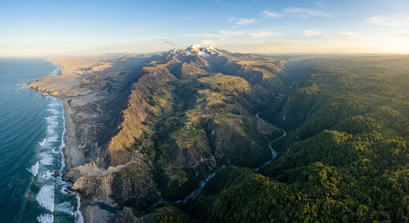
Peru's western edge is a narrow coastal desert — one of the driest on Earth — stretching from the Ecuadorian border to Chile, interrupted by river valleys that sustain both agriculture and ancient civilization. Moving east, the terrain rises sharply into the Andes, a highland world of altiplano (high plateau), colonial cities, Incan ruins, and mountain passes that routinely exceed 14,000 feet. Then, descending the eastern slopes, the Andes dissolve into the vast Amazon basin, which covers more than half of Peru's total land area and contains biodiversity that has no parallel anywhere else in the Western Hemisphere.
These aren't just scenic differences. They represent fundamentally different climates, cultures, logistical challenges, and travel rhythms. The step-by-step approach below is designed to help you think through the country's geography honestly — so that whatever you choose to visit, you're choosing it with eyes open rather than defaulting to a single famous site.
What you will need
How to Plan a Geographically Aware Peru Trip
Working through these steps before booking anything will save considerable frustration. Peru rewards deliberate planning far more than spontaneous improvisation — particularly because of altitude, permit requirements, and the country's sheer size.
Map Peru's three geographic zones before opening a booking site
Before looking at any flights or accommodations, spend time with a physical or topographic map of Peru. Identify the three major zones: the Costa (coastal desert), the Sierra (Andean highlands), and the Selva (Amazon basin). Note which cities anchor each zone — Lima on the coast, Cusco and Arequipa in the highlands, Iquitos and Puerto Maldonado in the Amazon.
This spatial understanding is the foundation for everything that follows. It immediately clarifies why a trip that tries to cover all three zones in under ten days is likely to feel rushed, and why choosing a primary zone and adding one secondary excursion often produces a richer experience.
Decide which geographic zone anchors your trip
Choose one zone as your primary focus based on what genuinely interests you — not what appears most in travel photography. The highlands offer Incan archaeology, colonial architecture, and high-altitude trekking. The coast offers archaeological sites like Chan Chan and Caral, the Nazca Lines, and Lima's acclaimed culinary scene. The Amazon offers wildlife, river travel, and ecological immersion unlike anywhere else in the Western Hemisphere.
There's no wrong choice. The mistake is treating Machu Picchu as a default anchor when your actual interests might align more closely with coastal archaeology or Amazon ecology.
Account for altitude in your travel sequence
If your itinerary includes the highlands, plan your arrival sequence to allow for acclimatisation. Flying directly from a sea-level city into Cusco is common but physically demanding. Many experienced travelers to this region recommend spending one or two nights in a lower-altitude highland city — Arequipa at around 7,660 feet, for instance — before ascending further.
Build at least two full rest days after arriving at high altitude before attempting strenuous activities like trekking. This isn't a luxury; it's a logistics variable that affects every day that follows.
Investigate permit and booking requirements early
Several of Peru's most visited sites operate with entry permits that sell out weeks or months in advance. The Inca Trail to Machu Picchu, for example, has a strict daily permit limit and frequently sells out long before the departure date. Huayna Picchu and Machu Picchu Mountain, the peaks visible in the iconic citadel photographs, also require separate timed-entry reservations.
Research permit availability for any specific site or trek you're considering before finalizing your travel dates — not after. Availability constraints should shape your planning calendar, not the other way around.
Evaluate domestic transport options between regions
Domestic flights connect Lima to Cusco, Arequipa, Iquitos, Puerto Maldonado, and other regional hubs. For trips crossing two or more geographic zones, flying between major cities is often the most practical choice — not because overland travel is impossible, but because the time savings are substantial and the route options between some regions are genuinely limited.
If overland travel between regions is part of your plan, research road conditions, journey times, and available services in advance. Some routes involve mountain passes prone to weather disruptions, particularly during the wet season (roughly November through April in the highlands).
Think in Regions, Not Attractions
Rather than building an itinerary around a checklist of famous sights, consider anchoring each trip segment to a geographic region and letting multiple experiences emerge from that base. This approach tends to reduce transit stress and deepen the quality of each stop. A week grounded in the Lake Titicaca region, for instance, opens up Puno, the altiplano, island communities, and cross-border context with Bolivia — far more than a single-day excursion would allow.
Common Misreadings and How to Avoid Them
Even well-prepared travelers tend to carry a few assumptions that Peru quickly complicates.
The altitude surprise. The single most predictable planning error is underestimating how altitude affects the body. Cusco, the gateway city to Machu Picchu, sits at roughly 11,150 feet above sea level. Arriving from Lima — a sea-level city — and heading straight to a demanding highland trek is a recipe for altitude sickness, which can range from headache and nausea to, in rarer cases, more serious conditions. See our guide to altitude and acclimatisation in Peru's highlands for a grounded account of what to expect and how to prepare.
The distance illusion. Peru is large — comparable in land area to Alaska — and overland travel between regions can take far longer than maps suggest. A bus journey from Lima to Cusco, for example, runs roughly 18 to 22 hours even on established routes. Domestic flights exist and are widely used, but weather-related delays in highland airports are not uncommon. Building buffer days into any multi-region itinerary is practical, not excessive.
The single-season assumption. Peru doesn't operate on a single wet or dry season. The coastal desert around Lima is cool and fog-shrouded during the Southern Hemisphere winter (June–October), while the highlands experience their dry season — typically the most visited window — during those same months. The Amazon has its own rhythm entirely. A trip that crosses all three zones may encounter three distinct seasonal realities simultaneously.
For travelers who've wrestled with similar logistical complexity in other destinations, the comparison with New Zealand's South Island is instructive: visually iconic places often obscure how much logistics, weather, and distance shape the actual experience on the ground.
Verify Entry and Safety Information Before You Travel
Travel conditions, visa requirements, health entry rules, and safety advisories change. Always verify current requirements with the U.S. Department of State's Peru travel page and official Peruvian government sources before finalizing plans. Do not rely on travel articles — including this one — as a substitute for official, up-to-date guidance.